
Welcome to Neah Bay, Washington
Directions to Neah Bay and Hobuck
Hobuck Beach Resort is located in the town of Neah Bay, on the Makah Reservation, at the northwest corner of Washington State. It is approximately 4.5 hours west from Seattle. Want to visit the most northwest corner of the continental United States? A few miles north is the popular Cape Flattery trail which provides the best access to this rare viewpoint. To the south of the resort lies a portion of the Olympic National Park and beautiful Shi Shi Beach.
From the Edmonds/Kingston Ferry:
- Take the Edmonds-Kingston ferry to Kingston, approximate crossing time is 35 minutes.
- Exit ferry, continue straight onto WA-104 for nearly 8 miles, traveling through the community of Port Gamble, and continue through town staying on the main road which will turn 45 degrees to the left.
- Turn right onto the Hood Canal Bridge and continue on 104 for 15 miles, then 104 will merge with 101, and continue on 101.
- Travel 37 miles to Port Angeles, at Lincoln St/US-101 turn left and follow 101 for 5.5 miles.
- Turn right at WA-112 and stay on 112 for 38 miles, turn right to stay on 112 and continue another 22 miles, turn right again to stay on 112 and travel 3 miles into Neah Bay.
From Neah Bay:
- Highway 112 turns into Bay View Avenue as you arrive into Neah Bay. Please stay on the paved road. (Do not follow your GPS directions.)
- Continue traveling on Bay View Avenue to the west end of town and you will then follow the large left curve onto Fort Street.
- At the intersection of Fort and 3rd Avenue, take a right.
- Go one block and watch for signage, you will take a left turn onto Cape Flattery Road.
- Turn left on Hobuck Beach Road and take a right at the Y after the bridge, onto the gravel road.
- Travel .5 miles until you reach the Hobuck Beach Resort office on your right.
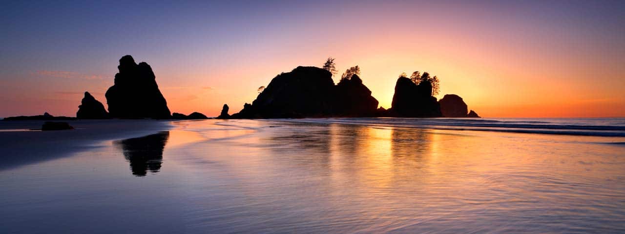
Shi Shi Beach
Visitors arrive from all over the world to enjoy the adventure of Shi Shi Beach. The trail consists of a great mix of rainforest hiking and beach walking. Make this an easy day hike or enjoy it as a backpacking trip with a night out on the beach. It is also possible to continue along the beach and hook up with the Ozette Loop hike or on to Hole in the Wall near La Push at Rialto Beach. There are many options but make sure you carry a tide chart with you so that you don’t get isolated by high tides at the headwalls if you plan to continue south past the Point of Arches. For information regarding the area along the beach designated as National Park please consult the website Olympic National Parks Website
Shi Shi Beach Trail
- 2 miles from the parking area to the beach
- 2.5 miles from the end of the trail along the beach to the Point of Arches
Makah Recreation Pass is required for parking at the trail head. One pass per vehicle is required. Please check for locations for purchase.
Amenities:
- Restrooms – located at the trailhead and designated locations along the beach
- Day use parking is located at the trailhead
Difficulty: The trail through the forest to the beach is slightly undulating but has no significant gain in elevation. Expect mud, bridges and boardwalks that may be slippery. The trail is well maintained and navigation is easy.
Pets: Pets are permitted along the trail but are not permitted past the National Park Boundary after 1.7 miles.
Directions to Shi Shi Beach
Continue through town heading west along Bay View Avenue for 1 mile. Bay View Avenue becomes Cape Flattery Road if you follow the yellow lines on the pavement. The road will turn sharply left then after 0.1 miles turn sharply right once you get to the west side of the main downtown area. Follow the signs past the clinic for 0.1 miles and turn sharply left again and follow the road along the foot of Bahokus Peak. You will be on Cape Flattery Road. After 2.5 miles follow the signs and turn left on Hobuck Road across the Wa’atch River. At the first intersection after the bridge go straight and follow the signs for the Fish Hatchery. The parking area is located on the right side of the road.
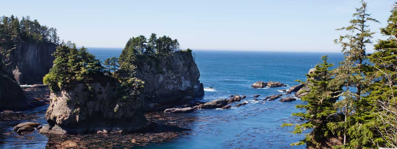
Cape Flattery and Tatoosh Island
From the tip of this scenic trail, you can view Tatoosh Island while standing on the most northwesterly tip of the contiguous lower 48 States. Four observation decks on the Cape Flattery Trail provide spectacular views of the rugged rocks, birds, and jade waters of the Pacific Ocean. The Pacific takes on many hues depending on the weather and cloud cover from steel gray to light pink or yellow at sunset. Watch for gray whales off the Cape and sea lions on Snake Rock just east of Tatoosh Island.
The Makah Tribe renovated the trail with a $170,000 Department of Natural Resources grant and an $85,000 State Department of Transportation grant. Also, seven Tribal youth members learned construction skills and earned funds toward college scholarships for donating 900 hours through the AmeriCorps project.
Cape Flattery Trail Information
Difficulty: Expect boardwalks, stairs, and dirt sections. There is an overall elevation loss of 200 feet. A moderate amount of exertion is required to get back to the parking lot.
Directions to Cape Flattery Trail
Continue through town heading west along Bay View Avenue for 1 mile. Bay View Avenue becomes Cape Flattery Road if you follow the yellow lines on the pavement. The road will turn sharply left then after 0.1 miles turn sharply right once you get to the west side of the main downtown area. Follow the signs past the clinic for 0.1 miles and turn sharply left again and follow the road along the foot of Bahokus Peak. You will be on Cape Flattery Road. Continue for another 5.1 miles to the trailhead.
Please be respectful and do not remove natural items such as, but not limited to plant, animals or shells. Please do not litter or drive on the beaches. Please limit your activities to designated visitor facilities.